Year 5 Geographers
This afternoon we have been learning all about the characteristics of the Boreal forest. We...
Read More

This afternoon we have been learning all about the characteristics of the Boreal forest. We...
Read More
Year 5 have been learning all about Moscow including the human and physical features of the...
Read More
Year 5 have been working really hard using ICT to aid their research project all about Edinburgh....
Read More
In Year 6, we have been learning all about time zones. We learnt that earth is split up into...
Read More
Year 5 have produced some amazing work today where we learnt all about Edinburgh. We used atlases...
Read More
Year 5 have been learning all about the Tundra. We have learnt that there are two different types...
Read More
We have been looking at volcanoes; their locations, how they are formed and the positives and...
Read More
Year 5 have been learning all about the Tundra and the different ways in which animals have...
Read More
Year 5 have been learning all about Europe and included reading as part of this. We looked at an...
Read More
Year 2 have produced some wonderful work today. We have learnt all about landmarks in England. We...
Read More
Year 5 have been learning all about Europe in their geography unit. We cannot believe the...
Read More
ELSECAR HOLY TRINITY PRIMARY SCHOOL
GEOGRAPHY
At Elsecar Holy Trinity Primary School, we have designed our geography curriculum with the intent that our children will develop a genuine curiosity and fascination about the ever-changing world and its people that will remain with them for the rest of their lives. We want our children to have the desire to travel and explore as many places as they can and continue to expand their geographical knowledge as they grow up.
We will deliver a geography curriculum that ensures our children:
Geography is taught through four main strands, as written in the National Curriculum 2014 National Curriculum - Geography key stages 1 to 2 (publishing.service.gov.uk):
Long Term Plan
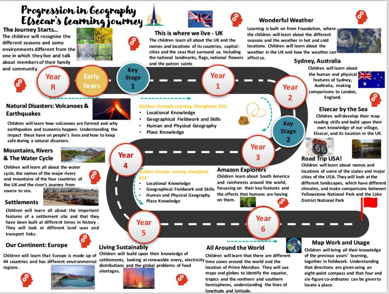
Learning in Geography starts in the EYFS, where children work towards meeting the Early Learning Goals set out in the Early Years Foundation Stage Statutory Framework 2021 (Statutory framework for the early years foundation stage (publishing.service.gov.uk) and Development Matters 2021 (Development Matters - Non-statutory curriculum guidance for the early years foundation stage (publishing.service.gov.uk). We have written our curriculum, so that Geography is also taught through the four strands in EYFS.
Human and Physical Geography
In EYFS, children recognise some environments that are different from the one in which they live. They learn about a range of contrasting environments within both their local and national region. Key vocabulary needed to name specific features of the world – both natural and made by people, are modelled to the children. Non-fiction texts are shared that offer an insight into contrasting environments. Children develop an understanding of the effect of changing seasons and the weather on the natural world around them. Children are provided with opportunities to note and record the weather and texts are shared with the children about the changing seasons. Throughout the year, children go outside to observe the natural world and observe how animals behave differently as the seasons change (hibernating animals – hedgehogs, bats, and dormice). Children in EYFS visit the seaside to gain a real experience of contrasting environments.
In KS1, children build on their knowledge from EYFS and develop a more secure understanding of what ‘human’ and ‘physical’ features are. Through studying the UK, children name and locate key humans and physical landmarks on a map, such as Blackpool Tower and the White Cliffs of Dover. They continue to identify seasonal and daily weather patterns in the UK and the location hot and cold areas of the world in relation to the Equator and the North and South Poles, through their unit on ‘Wonderful Weather’. In Year 2, children carry out a comparative study of Sydney, Australia and London. During this unit, they study the human and physical features of both cities and begin to understand that areas within a place, such as Sydney, are different depending on the human and physical features. Children in Year 2 start to develop pros and cons of living in London or Australia, which forms the basis of debate in later years. At the end of KS1, children visit the coast and use a map to navigate around a seaside town, identifying key human and physical features. Throughout their learning of human and physical features, children develop their geographical vocabulary and understanding, including of beach, cliff, coast, forest, hill, mountain, sea, ocean, river, soil, valley, vegetation, season, weather, city, town, village, factory, farm, house, office, port, harbour and shop.
In KS2, children develop their learning about hot and cold places in the world, by learning about biomes and climates zone around the world. In Year 3, children learn about North America and study major cities of the USA and identify, name and locate key human landmarks on a map. To develop their knowledge of physical features, they study Yellowstone National Park and compare this to the Lake District National Park in the UK. Children also study the different landscapes across the USA (mountains, coasts, prairies, forests, and deserts). When studying the Amazon Rainforest unit, they will learn about vegetation belts, and the impact of humans on this physical environment, by learning about deforestation and ways they could limit their impact.
In Year 4, children study natural disasters, focussing on volcanoes and earthquakes. Children learn about what the Earth looks like underground and how volcanoes are formed. Children learn key vocabulary linked to volcanoes and Earthquakes, including tectonic plates, dormant, extinct, active. Children build on their debating skills by discussing reasons for and against living near a volcano and link this to human and physical features.
In Year 4, children continue their study of human and physical features, learning about the water cycle and journey of a river from source to sea. Geographical language is taught including source, mouth, erosion, meander, upper course, middle course and lower course, precipitation, evaporation, and condensation (the water cycle is also covered in science). During this unit, children learn about major rivers and mountains in the UK.
In Year 4, children develop their understanding of settlements. They learn about what a settlement is and why they are developed in certain locations. Children build on this by studying different types of land use including agricultural, retail, housing, business, industrial and leisure.
In Year 5, children continue to build on their knowledge of biomes and climate zones in their unit on ‘Our Continent: Europe’. Children look at environmental regions using maps, atlases and globes and learn about key physical features of each region (climate, soil, vegetation and animals). Children compare human and physical features of Edinburgh and Moscow.
In Year 5, children build on their knowledge from Year 4 Settlements, through their unit ‘Living Sustainably’. During this unit, children learn about trade links through studying where our food comes from, including food miles and the supply chain process. They learn about importing and exporting goods and the impact food miles have on climate change. In this unit, children also learn about the distribution of natural resources, focusing on electricity, including different ways in which electricity can be generated (wind, solar, biomass, water). Children learn that access to natural resources varies in different countries, studying food shortages in South and Central America.
In Year 6, children start to consolidate all their prior learning by studying the Earth. They identify similarities and differences between the climate in the UK and the Tropics. Through map work, children also consolidate their knowledge of land use and rivers and mountains.
Place Knowledge
In EYFS, children talk about members of their immediate family and community. This also links to study in PSHCE. Children share pictures of their family and look at examples from real-life and from books to learn about different types of families. Children name and describe people who are familiar to them and talk about people that they may have come across within their community – e.g., delivery and shop staff, hairdressers, the police, ambulance service, the fire service, nurses, doctors, and teachers. Children are visited by a member of the ambulance service.
In KS1, children continue to understand geographical similarities and differences through studying the human and physical geography of a small area of the United Kingdom (London), and of a small area in a contrasting non-European country (Sydney, Australia). Children regularly use maps, atlases, and globes to identify places and their features.
In KS2, children continue to understand geographical similarities and differences through the study of human and physical geography of a region of the United Kingdom (Edinburgh, The Lake District National Park, Sherwood Forest), a region in a European country (Moscow), and a region within North America (Yellowstone National Park) or South America (Amazon Rainforest).
Locational Knowledge
In EYFS, children begin to recognise some similarities and differences between life in this country and life in other countries. They are taught about places in the world that contrast with locations they know well (e.g., Elsecar). Children are given relevant, specific vocabulary to describe contrasting locations and images, video clips, shared texts, and other resources are used to bring the wider world into the classroom. Children’s compare their life to the lives of children in other countries, through studying how they travel to school, what they eat, where they live and so on.
In KS1, children continue to broaden their locational knowledge by learning about the capital cities and countries of the UK. Children identify the countries and capital cities of the UK on a map, atlas, and globe, and learn about key characteristics of each country, such as the national flower and patron saints (links to British Values). Children develop their understanding of scale beyond the UK, in the unit ‘Sydney, Australia’, where they name and locate the seven continents and five oceans of the world maps, atlases and globes.
In KS2, children further their knowledge of the world, by locating counties of the UK, as well as countries and major cities, using maps to focus on Europe, including the location of Russia (and Moscow) and North America and South America, concentrating on their environmental regions (biomes and climate zones), key physical characteristics (volcanoes, mountains, rivers) and human characteristics - key landmarks and land use patterns, including how these have changed over time.
In Year 6, children will identify the position and significance of latitude, longitude, Equator, Northern Hemisphere, Southern Hemisphere, the Tropics of Cancer and Capricorn, Arctic and Antarctic Circle, the Prime/Greenwich Meridian and time zones (including day and night) in their ‘All Around the World’ unit.
Geographical Skills and Fieldwork (Maps and Mapping Skills in EYFS)
In EYFS, children begin to use and interpret maps. They derive information from a simple map, including imaginative maps and they learn how to use a plan view to find and mark features. Children can follow a simple map using landmarks. Children are introduced to a globe and learn the location of the North and South Poles. Children are introduced to and learn more complex directional language. They draw and create simple maps from memory about features in a familiar environment and begin to use simple symbols on maps to show features and journeys. Children in EYFS start to gain some knowledge of their own country, their location, and its features. Through using digital maps (e.g., Google Maps / Google Earth), children begin to understand that you need to zoom out to see a larger area.
In KS1, children use world maps, atlases, and globes to identify the United Kingdom and its countries, as well as the countries, continents and oceans studied at this key stage (see above). Children begin to use simple compass directions (North, South, East and West) and locational and directional language [for example, near and far; left and right], to describe the location of features and routes on a map. In KS1, children develop their fieldwork and mapping skills through studying the school ground and local area. They use aerial photographs and plan perspectives to recognise landmarks and basic human and physical features. Following on from their learning in EYFS, children begin to devise their own simple maps, and use and construct basic symbols in a key. Children use simple fieldwork and observational skills to study the geography of their school and its grounds and the key human and physical features of its surrounding environment (Elsecar).
In KS2, children continue to develop their geographical fieldwork and skills using maps, atlases, globes and digital/computer mapping to locate countries (UK, European, North America) and describe features studied (rivers, mountains, lakes, forests, volcanoes/earthquakes, land use). Children use the eight points of a compass (Y4 Settlements, Y5 Our Continent: Europe, Y6 Map Work and Usage), and four and six-figure grid references (Y6 Map Work and Usage), symbols and key (including the use of Ordnance Survey maps) to build their knowledge of the United Kingdom and the wider world. They use fieldwork to observe, measure, record and present the human and physical features in the local area using a range of methods, including sketch maps, plans and graphs, and digital technologies.
Example of sequence of learning document
Click to enlarge


You must be logged in to post a comment.